
Loading CyneTax Platform…
Loading CyneTax Platform…
Digitize municipal property taxation with AI-powered mapping, satellite imagery, drone video, and 360° property visualization. Built for government bodies who demand accuracy.
Every module built for municipal accuracy — see the tools your field officers and tax administrators use daily.
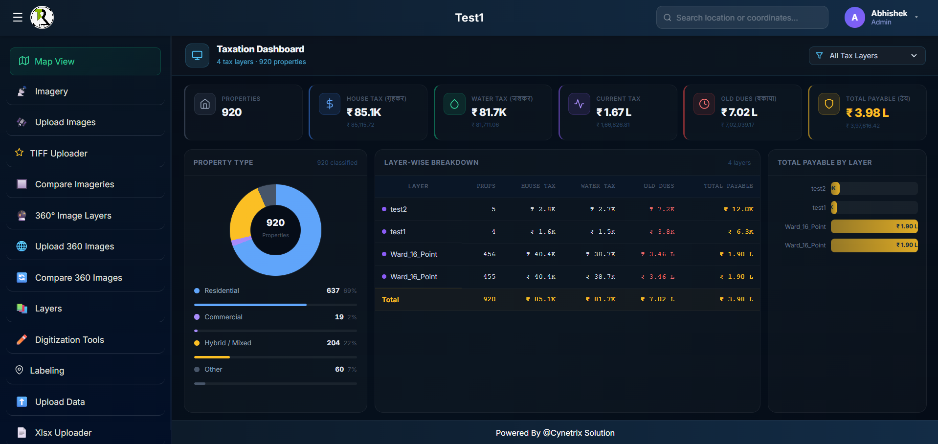
920 properties, 4 tax layers, ₹3.98L total payable — all visible in one taxation dashboard. Property type breakdown, layer-wise revenue analysis, and real-time collection metrics give administrators instant, irrefutable visibility into every ward's tax status.
Schedule a private walkthrough and explore the full taxation dashboard with your municipality's data.
Schedule DemoHigh-resolution aerial and satellite imagery pinned precisely on your GIS base map. Field officers can locate any property by GPS coordinates, zoom into drone-captured aerials, and validate structures against official records — all without leaving the platform.
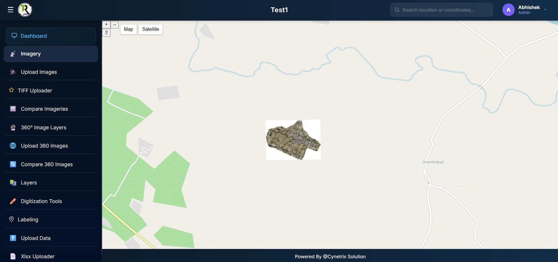
Explore satellite and drone imagery overlaid on live GIS maps — navigate, zoom, and inspect any property.
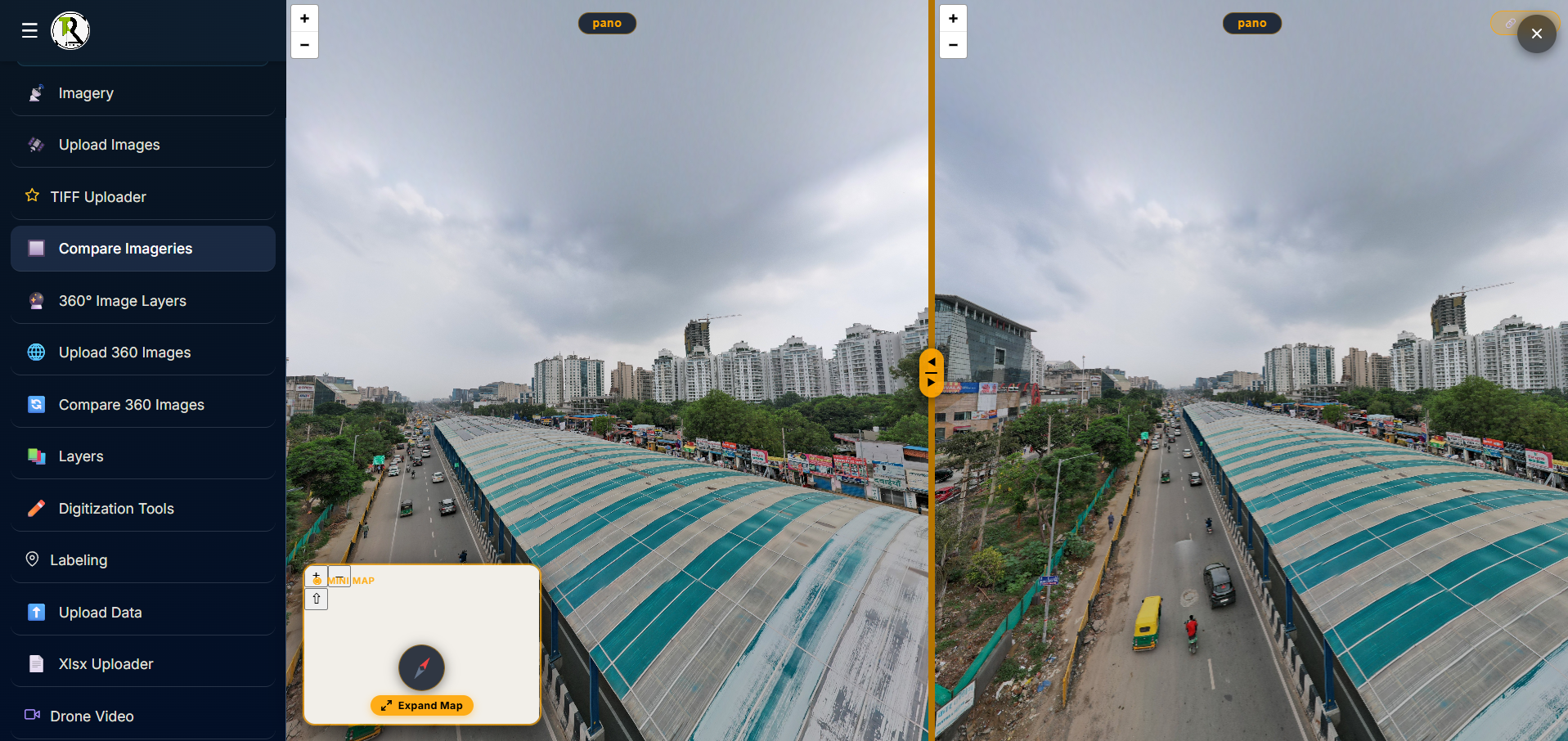
Schedule DemoPlace any two imagery layers side by side with a draggable divider to instantly identify new constructions, demolitions, or illegal encroachments. Multi-layer selection on the left panel lets you choose exactly which imagery dates and zones to compare.
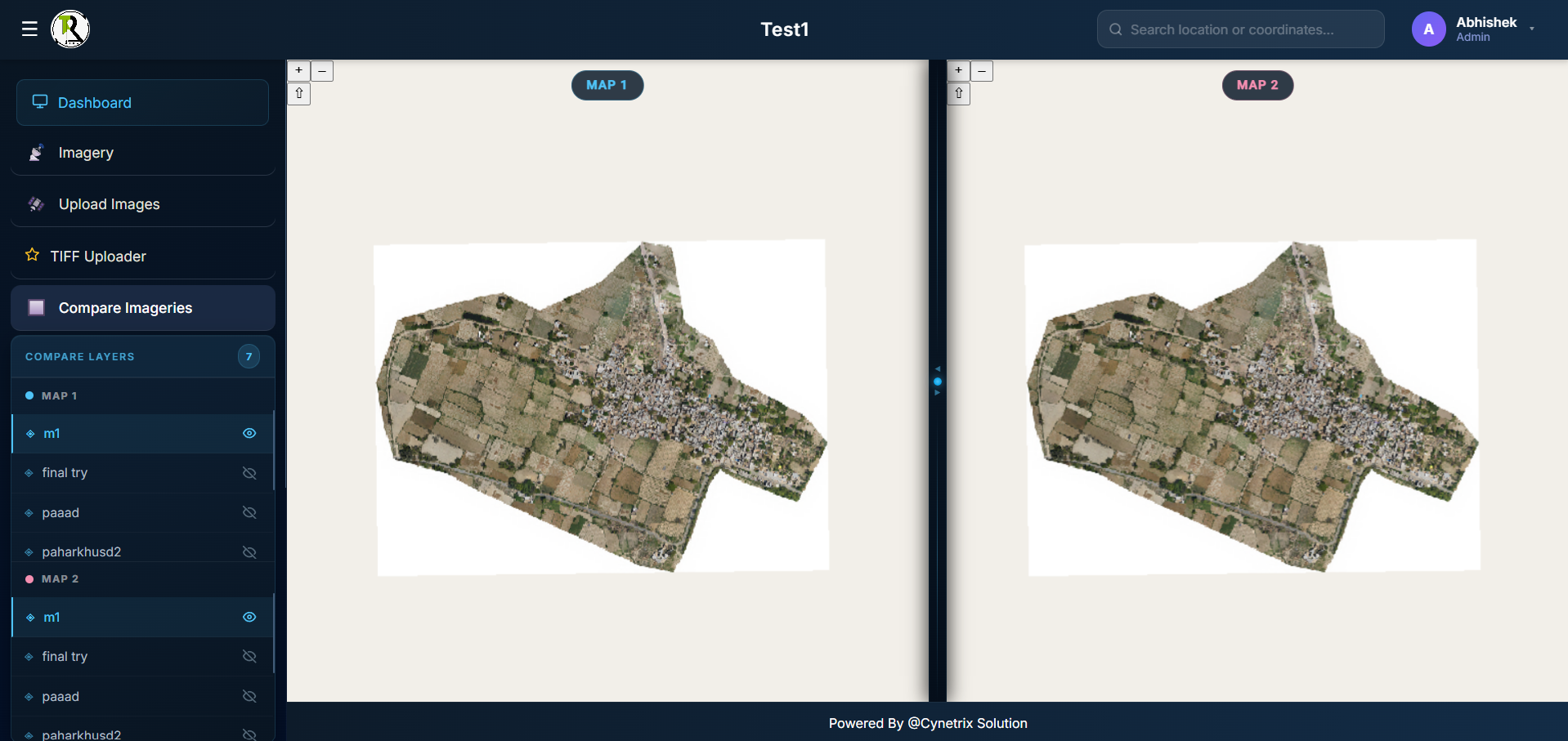
Watch side-by-side imagery comparison in action — drag the divider, switch layers, and detect property changes live.
Schedule DemoWalk through any street or neighbourhood virtually with panoramic 360° imagery. Field officers upload captures directly from site — these then appear as interactive layers on the GIS map, giving administrators a street-level ground truth for every assessment.
Experience 360° property visualization linked to GIS — navigate streets virtually and validate property data on-site.
Schedule DemoCompare two 360° panoramic captures of the same location from different dates with a synchronized split view. This is your visual evidence for dispute resolution — irrefutable, time-stamped, and court-admissible ground documentation of any property change.
See 360° before-and-after comparison live — drag the split, validate changes, and generate dispute-ready visual evidence.
Schedule DemoA comprehensive GIS-integrated property taxation platform designed for municipal corporations and government bodies. CyneTax combines satellite imagery, drone video, 360° property visualization, and advanced digitization tools.
Accurately map properties, automate tax assessment, and maximize revenue collection with unprecedented accuracy — all while giving field officers and administrators a single source of truth.
Municipal tax authorities faced critical obstacles — CyneTax delivers a complete, ground-truth solution.
Five powerful modules working in harmony to transform your municipal property tax administration
GIS-based complete property mapping, satellite and aerial imagery integration, drone video layers, 360° immersive visualization, and boundary digitization for precise property demarcation.
Multi-layer property information system with automated unique property ID generation, real-time attribute mapping, Excel/XLSX bulk upload, and comprehensive layer management.
Satellite imagery comparison tools, 360° panoramic image capture and upload, side-by-side 360° comparison for property changes, and drone video documentation for every assessment.
Mobile-enabled data collection, real-time location search and identification, on-site property validation with visual confirmation, and direct imagery upload from field teams.
Taxation dashboard with real-time revenue metrics, property change detection alerts, multi-jurisdiction comparison, automated audit trails, and comprehensive collection reports.
Automated generation of unique, permanent property identifiers tied to GIS coordinates — eliminating duplicates, preventing fraud, and enabling precise revenue attribution across wards.
Easy-to-use boundary marking, property labeling, and polygon drawing tools for field staff. Convert paper surveys into precise digital records in minutes, not weeks.
Import thousands of property records via Excel/XLSX with smart column mapping and validation. Export reports, audit logs, and tax notices in multiple formats for civic integration.
Enterprise-grade technology powering every feature of CyneTax
Enterprise-grade geospatial framework with satellite data integration
React-based dashboard with real-time map visualization
Microservices architecture for high-volume data processing
GIS-optimized database with PostGIS for precise queries
Machine learning for property detection and change identification
Role-based access, encrypted transmission, audit logging
Cloud-native architecture on Render for reliability
Satellite, drone & 360° image handling with enhancement
Measurable results from real municipal deployments across India
| Metric | Achievement |
|---|---|
| Revenue Increase | ₹25+ Crores annually |
| Tax Collection Accuracy | 98%+ data accuracy |
| Property Identification | 40% increase in coverage |
| Efficiency Gains | 80% reduction in manual work |
| Processing Speed | 10x faster property assessment |
| Dispute Resolution | 90% faster with visual evidence |
| Data Completeness | 99%+ record accuracy |
| Fraud Detection | 95% identification rate |
"CyneTax transformed our property tax administration. Within 4 months, we mapped over 2 million properties with 99% accuracy. Revenue jumped by ₹25 crores, and citizen complaints dropped 70% because we now have irrefutable visual evidence for every assessment."
Features no traditional municipal software can match
Comprehensive property documentation from three independent visual sources — aerial, drone, and street-level — all within one platform.
Current and historical satellite data comparison to detect new constructions, demolitions, and unauthorized changes automatically.
Machine learning algorithms automatically identify taxable properties, flag changes, and surface revenue opportunities hidden from manual surveys.
Easy boundary marking and property labeling that turns paper surveys into precise GIS-linked digital records — all usable by non-technical field staff.
Ward-wise, layer-wise, and property-type revenue insights with real-time collection status and compliance reporting for municipal leadership.
Role-based access control for commissioners, officers, and field staff. Full audit logs, encrypted data transmission, and on-premise deployment options.
CyneTax adapts to your jurisdiction — whether a ward office or a state revenue department.
Join municipalities across India already recovering crores in additional revenue with CyneTax. Get a personalized demo and see the difference in days, not quarters.