
Loading Cyne Visuals…
Loading Cyne Visuals…
Bring 2D mapping, 3D point clouds, and 3D mesh models into one workspace — with the analysis tools drone survey, GIS, and engineering teams actually need on top.
Three viewers, one workspace — see the tools survey, GIS, and engineering teams use on every project.
Upload large orthomosaics (GeoTIFF/COG), tiled for smooth pan and zoom. Draw and edit points, lines, and polygons directly on the map with custom styling, labels, and a full attribute table. Bring in existing layers from GeoJSON, KML, Shapefile, DXF, or Excel/CSV — with column mapping for lat/lon — and export back out to CSV.
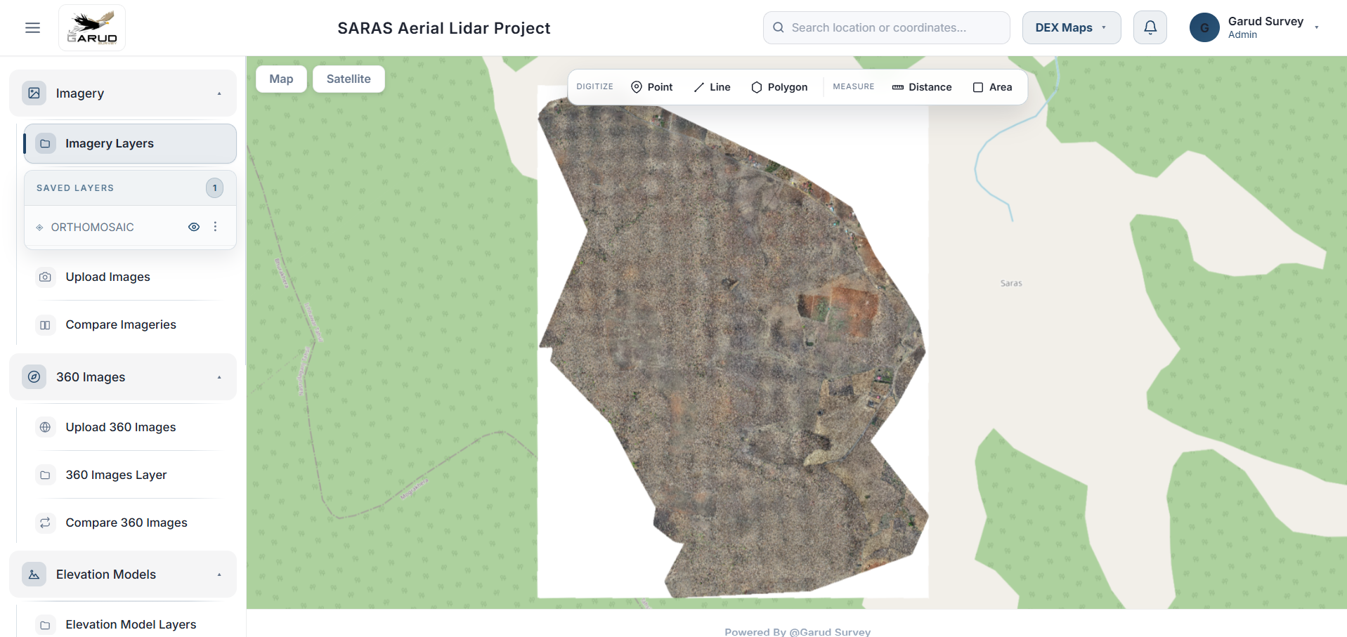
Schedule a private walkthrough and explore the full 2D mapping workspace with your own survey data.
Schedule DemoUpload DEM/DSM rasters — auto-converted to Cloud-Optimized GeoTIFF with automatic hillshade generation. Trace true contour lines directly off the elevation raster (not a coarse grid approximation), with configurable interval, index-contour labelling, and automatic filtering of small terrain-noise artifacts. Draw a line and get an instant elevation profile chart with cross / L / X section modes.
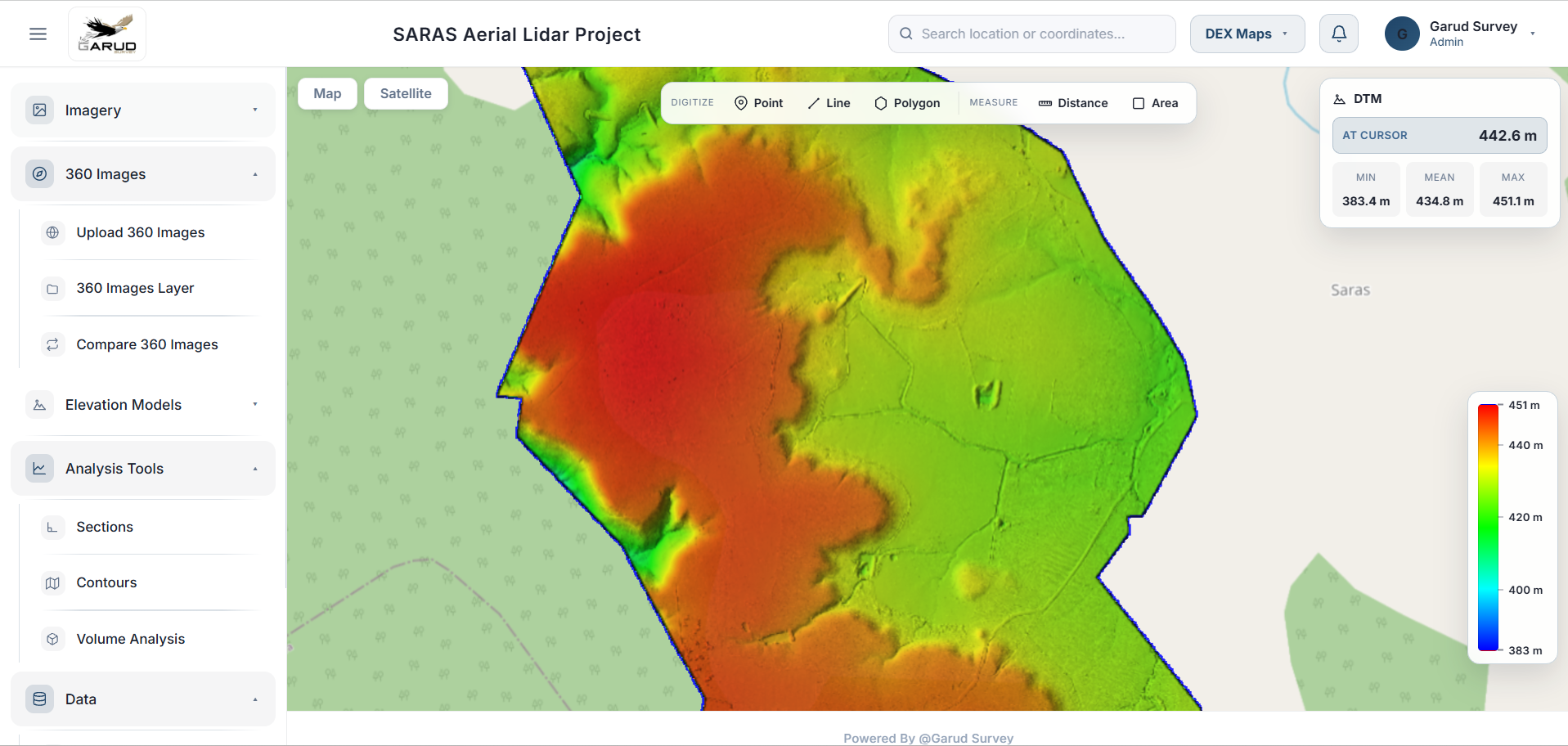
Watch contour tracing and elevation profiles generated live from your own DEM/DSM data.
Schedule DemoCompute volume between two surveyed surfaces, against a reference elevation, or within a hand-drawn or uploaded boundary — with a full saved-analysis history. For sites surveyed repeatedly over time, compare imagery, elevation, and volume across survey periods side-by-side and with a swipe control.
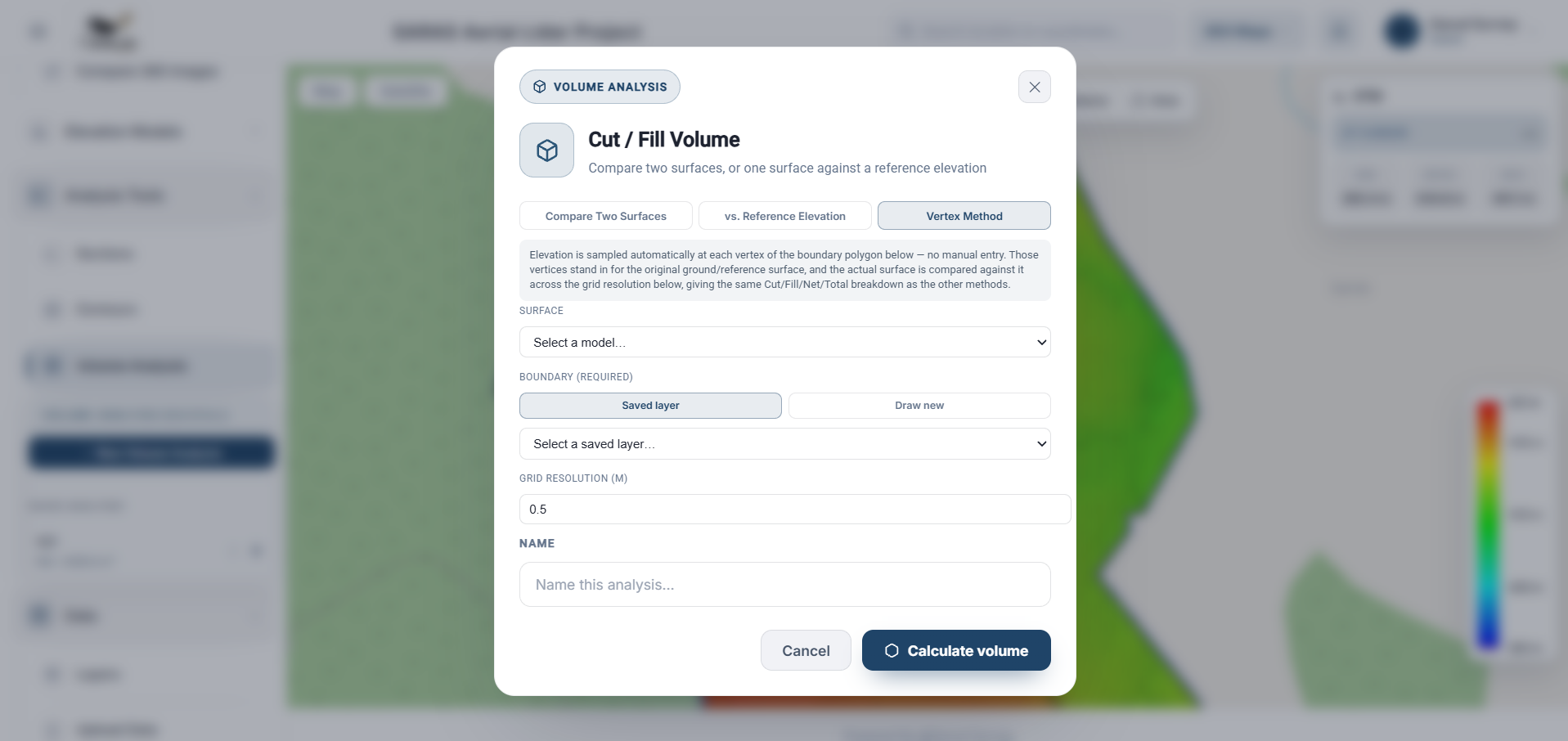
See cut/fill volume computed against a reference surface and compared across survey dates.
Schedule DemoA dedicated viewer for LiDAR and photogrammetry point clouds (COPC/LAS), with the same GIS annotation and cross-section tooling as the 2D map — plus a realistic sky and lighting backdrop for a true 3D walkthrough feel.
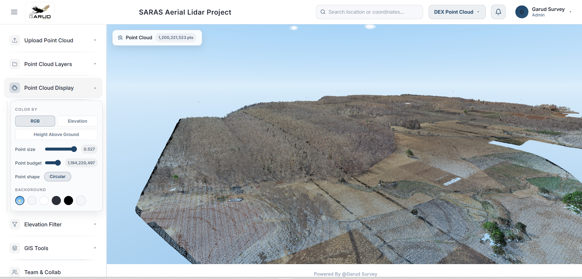
Explore a COPC/LAS point cloud with cross-sections and on-cloud digitization in a private session.
Schedule DemoFull textured 3D model viewing supporting OBJ/MTL, textured PLY, GLTF/GLB, FBX, and STL. True trackball rotation and pan, measurement of length, area, angle, and 3D vertical height directly on the model's real surface, live cursor elevation readout, and point/line/polygon digitization saved into toggleable layers.
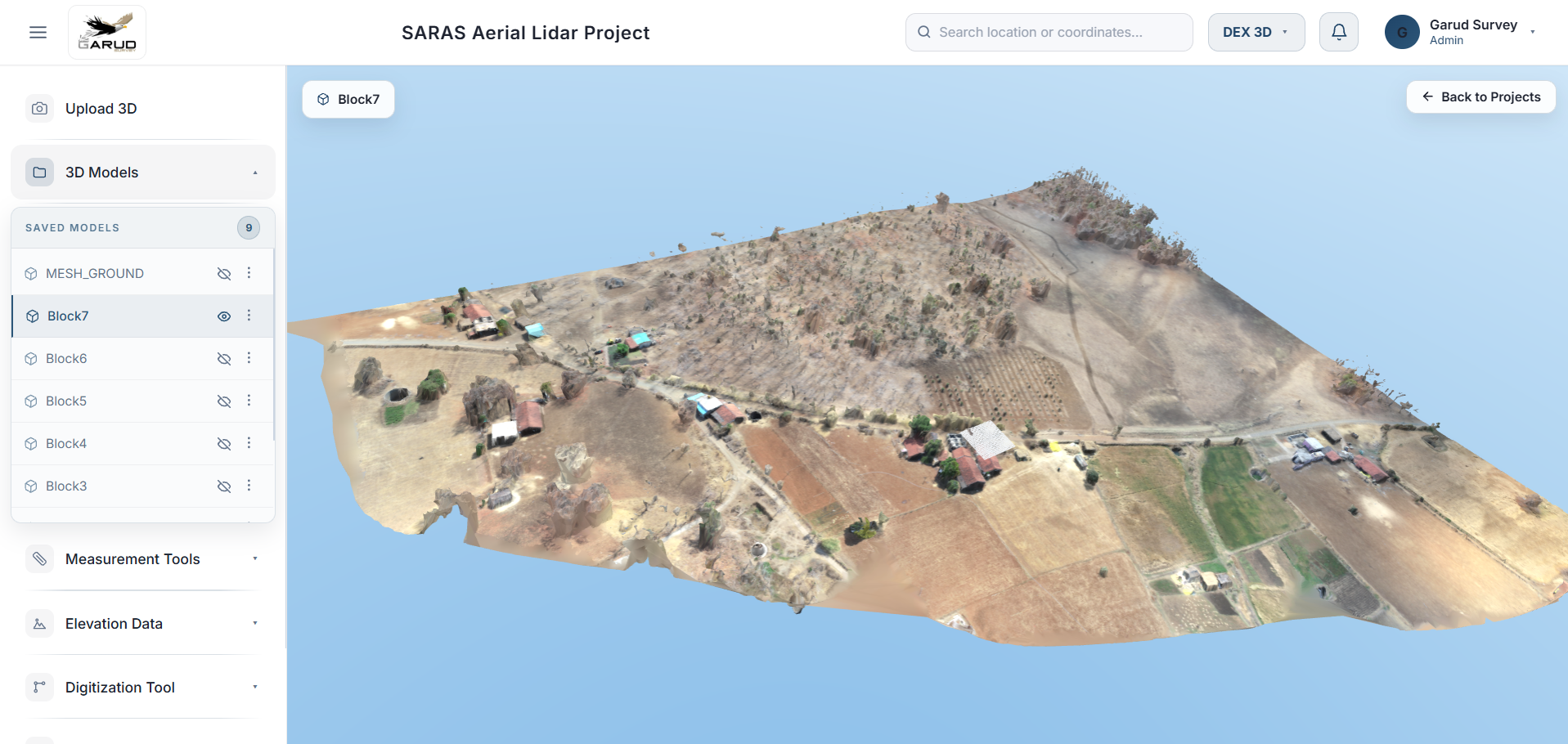
Load a textured mesh and try on-surface measurement, flood simulation, and shadow analysis live.
Schedule DemoCyne Visuals is a survey and geospatial data platform built for drone survey, GIS, and engineering teams — bringing 2D mapping, 3D point clouds, and 3D mesh models into one workspace.
It is organized around three core viewers — Cyne Maps, Cyne Point Cloud, and Cyne 3D — plus the project and team management that ties them together, with survey/period-based organization for sites tracked over time.
Each viewer is purpose-built, and they share the same annotation, measurement, and elevation tooling.
Eight modules working across all three viewers to turn raw survey data into decisions
Upload and view large orthomosaics (GeoTIFF/COG), tiled for smooth pan and zoom, alongside vector layers organized for the whole team.
Draw and edit points, lines and polygons directly on the map or 3D surface, with custom styling, labels and a full attribute table.
Bring in existing layers from GeoJSON, KML, Shapefile, DXF or Excel/CSV — with column mapping for lat/lon — and export back out to CSV.
DEM/DSM rasters auto-converted to Cloud-Optimized GeoTIFF with automatic hillshade, plus true contour tracing off the raster with index labelling.
Draw a line and get an instant elevation profile chart, with cross / L / X section modes and model-synced hover on 3D surfaces.
Compute volume between two surveyed surfaces, against a reference elevation, or within a boundary — with a full saved-analysis history.
For sites surveyed repeatedly over time: side-by-side and swipe comparison of imagery, elevation and volume across survey periods.
Invite teammates with per-project access and leave location-pinned comments with status tracking (open / pending / closed) visible to the whole team.
Two analysis tools in Cyne 3D that go beyond viewing the model
Elevation-based inundation modelling: raise or lower a water level and watch the model flood realistically from its lowest points upward — rendered as animated, natural-looking water, not a flat plane, but a true elevation-aware simulation.
Real sun-position-driven shadow casting: scrub a 24-hour time slider and watch accurate shadows move across the model, based on actual solar geometry for the current date.
Length, area, angle and 3D vertical height measured directly on the model's real surface — plus a live cursor elevation readout and elevation profile charts with model-synced hover.
Drag to orbit in any direction, including roll, with natural pan — the model behaves the way survey and engineering reviewers expect it to.
Workspace and access management built around how survey work is actually organized
Separate workspaces per site, with survey/period-based organization for sites tracked over time
Admins manage projects and teammates; teammates get full working access scoped to their assigned projects
Team comments pinned to a map location with open / pending / closed status, visible to everyone on the project
Auto-detects or lets you set a project's coordinate reference system
Geolocated panorama markers and drone video playback tied to the map
Group captures by survey date so imagery, elevation and volume can be compared across time
Cyne Visuals fits any team working with drone survey, GIS, and 3D reality-capture data.
See Cyne Visuals with your own orthomosaics, point clouds, and 3D models. Get a personalized walkthrough of the viewers and analysis tools your team would use every day.
Looking for a GIS technology partner? Let's talk about your platform or project.
25A, Pink City
Lucknow, India — 226017
+91-7905343725
+91-6387411503
contact@cynetrix.co.in
www.cynetrix.co.in